Better and cheaper soil sampling with DynaCrop
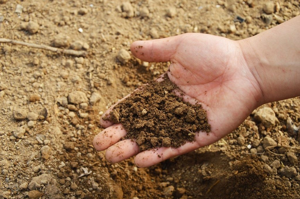
Soil is crucial for farmers because it is the main source of essential nutrients and water that plants need to grow effectively. Soil fertility directly influences crop productivity, making it essential for the sustainability of agriculture. To ensure the health and productivity of their crops, farmers need to regularly check the quality of their soil. One way of assessing soil condition is through soil sampling, where samples are taken from different parts of the field and analysed in specialised laboratories. This provides farmers with valuable information such as nutrient levels, pH, organic matter and other important soil properties. By using satellite data to determine the optimal locations for soil sampling points, farmers and soil sampling service providers reduce the need for extensive and random sampling across the field.
However, with multiple soil sampling methods available nowadays, determining the most relevant, valuable, and cost-effective approach for specific fields remains an intriguing question. This article aims to provide insights that can help soil sampling providers or farmers to achieve the following savings:
- By optimizing fertilizer application based on soil characteristics, farmers can reduce fertilizer expenses by around 15% annually.
- With a better understanding of soil characteristics, farmers can optimize irrigation practices and reduce water usage by approximately 20% to 30%.
- By addressing soil issues and implementing appropriate soil management practices, farmers can achieve yield improvements ranging from 5% to 15%.
- By focusing on specific areas of the field that require attention, farmers can save approximately 10% to 15% of their time spent on field operations.
The soil quality is influenced by various factors like the type of soil, how the land was used before, and how it was managed. To ensure the soil samples represent the whole field accurately and not just random parts, it is important to check the soil’s variability before taking samples. This helps ensure that the collected samples truly reflect the overall condition of the soil. However, on-site mapping of soil, one of the most common methods, does not take into account any information about soil variability. Despite the fact that conducting on-site mapping of soil costs both money and time and involves many necessary measurements to create detailed soil maps.
Although modern technology like electrical conductivity scanners has shown potential for soil mapping, the execution costs remain high. Therefore, in this article, we concentrate on describing and highlighting the benefits of remote sensing for soil sampling.
Remote sensing is a powerful method for soil mapping that offers several advantages over other techniques. It can be adopted globally on a large scale and at a low cost, making it an accessible option for soil analysis. It provides valuable information about soil qualities, which can be utilized to optimize the placement of soil sampling points. Watch our dedicated webinar, to find out more about satellite soil mapping approaches.
Soil sampling strategies
There are several sampling strategies which are used in practice. In this article, we focus on the following three main types: Grid-based sampling, sampling based on electrical conductivity (EC) scanning, and sampling based on remote sensing.
1. Grid-based sampling
This method is very straightforward as it includes the use of a grid which divides the field into uniform cells (sub-areas), e.g. 1, 3 or 5 hectare squares. The samples are then taken from the center of each cell or in a specific pattern in case more than one sample is taken from each grid cell.
Grid-based sampling can capture the variability of the soil but the reliability or rather the representativeness of the samples dramatically decreases when a larger grid is used or when the soil variability is high. This can lead to critical false assumptions about soil nutrients and fertility as some parts of the field with high or low fertility can easily become unnoticed. Another disadvantage of this method is that some samples can be redundant when multiple samples are taken from a homogenous part of the field. This can be costly as the number of samples which are taken from each field is usually quite small.
2. Sampling based on electrical conductivity scanning
Electrical conductivity soil scanning is a survey that takes hundreds of soil readings per hectare using a sensor, e.g. EM38MK2, which travels the whole field, typically behind a car, tractor or an ATV, taking readings of shallow and deep conductivity, and logging the position of each reading. Conductivity variation is caused by a number of factors, principally soil type and water holding capacity but stone content, soil depth and compaction all have an effect as well. The whole field is scanned and a zonation map is prepared from the readings which is then used to take soil samples from areas with different electrical conductivity.
A great approach for producing high-resolution soil maps, however, the cost of soil scanning per hectare is high and the service is not available to all farmers worldwide.
3. Sampling based on remote sensing
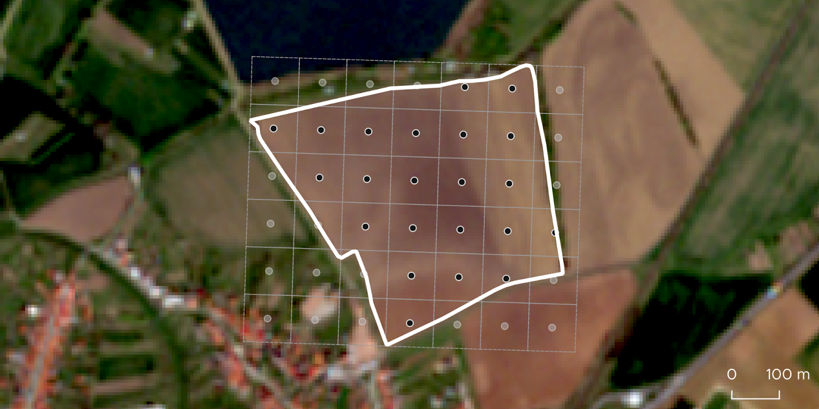
There are two main remote sensing methods which can be used to map soil variability. The first one involves the use of aerial or satellite observations of bare soil which hold valuable information about soil reflectance in different parts of the electromagnetic spectrum. Bare soil reflectance is affected by organic matter, texture, moisture and mineral composition and for optimal results imagery from dryer periods should be used. The soil variability which is captured in this way can be used to create zonation maps for the soil sampling as presented in Image 4 below.
within each sub-zone
The second method is mostly unique to satellite remote sensing as it involves the use of multiple satellite observations from past seasons, optimally from the past 5 or more seasons, which capture crop growth variability in each season. These satellite observations are then fused together creating a map of long-term yield potential which delineates stable recurring zones with different productivity.
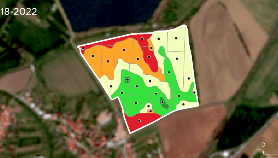
Image 5 below shows crop growth variability from seasons 2018 to 2022 where a recurring growing pattern can be observed. Image 6 then shows the yield potential map, which was computed from the individual seasons, with sampling points placed in parts of the field with different crop performance.

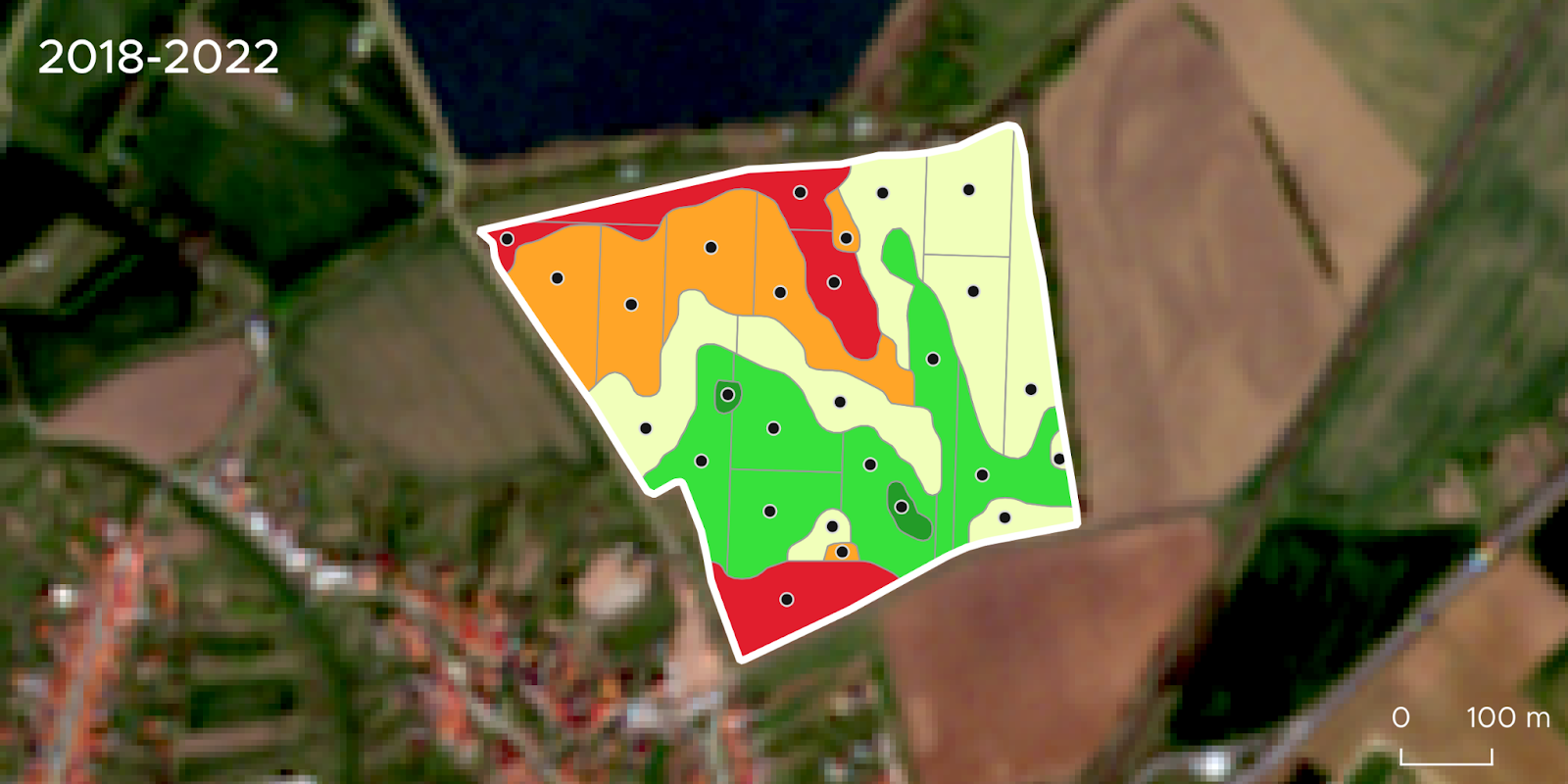
Although crop growth and yield in each season are affected by many factors, the repeating growing patterns carry key information about soil fertility and for this reason, the yield potential map is a great source of information which can be used to take representative soil samples in parts of the field where there are clear differences in crop growth and thus different soil attributes are expected. Additionally, the yield potential maps can also be used for tissue sampling, variable rate fertilizing and variable rate seeding. Also after finding the weak zones, farmers can also consider regenerative agriculture methods which cure the soil and increase its fertility.
Benefits of satellite-powered soil sampling
The main advantage of using satellite remote sensing for soil mapping is that these methods can be used at a very low cost as they do not require any on-site measurements. Moreover, the analysis of crop growth patterns and yield potential from satellite imagery provides unique information about each field which can not be obtained from other sources on a large scale. Up-to-date maps can be generated at 3 or 10-meter resolution depending on the satellite which is used (PlanetScope: 3m, Sentinel-2: 10m).
On average, it is estimated that this method results in cost savings ranging from 20% to 40% compared to grid-based sampling or electrical conductivity scanning-based zoning. These savings can be attributed to reduced labour costs, equipment expenses, fuel consumption, and field sampling efforts. Throughout the entire process, from soil sampling optimization to the correct application of fertilizers and variable rate seeding, per hectare, farmers save from €50 to €100 or more.
At DynaCrop, we offer cutting-edge tools that utilize satellite data to create prescription maps, allowing for a better understanding of both crop and soil heterogeneity. Our services also include optimizing sampling point distribution based on satellite-observed soil conditions. In the coming season, to maximize field productivity and profits, we invite you to join us on this journey towards a more sustainable and efficient agriculture sector. Let’s have a call and explore how we can unlock the true potential of our soils, paving the way for a greener future.
| Soil sampling | Sampling optimization | Soil quality analysis | Soil fertility optimization | Crop productivity improvement | Nutrient level assessment | pH analysis | Organic matter evaluation | Soil property assessment | Satellite data utilization | Soil variability mapping | Cost-effective soil sampling | Precision agriculture technology | Grid-based soil sampling | Electrical conductivity scanning | Remote sensing for soil analysis | Fertilizer optimization | Efficient irrigation practices | Water conservation techniques | Yield enhancement strategies | Time-saving field operations | Soil type | Comprehensive soil variability analysis | Zonation mapping for soil sampling | Crop growth monitoring | Long-term yield potential mapping | Sustainable soil management | Precision nutrient application | Optimized soil moisture management | Data-driven decision making | Greener agriculture practices | Data-driven decisions | Precision farming |